Sobre ríos y canales - Aspectos geográficos y cartográficos en el legado de Humboldt
DOI :
https://doi.org/10.18443/251Mots-clés :
Humboldt, Kartographie, Bergbau, Flüsse, BifurkationRésumé
Zusammenfassung
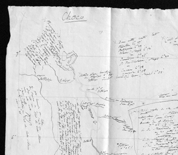
Anhand von unpublizierten Beispielen aus dem Nachlass Humboldts soll ein wichtiger Aspekt seiner Reise vorgestellt werden: Nach seinen Messungen, berechnete er die Ergebnisse mit mathematischen Methoden, zeichnete Karten und verglich diese mit denen seiner Vorgänger. Später publizierte er Karten von hoher Qualität und gab zur Vervollständigung anderen Reisenden Ratschläge, um in Regionen zu messen, die er nicht selbst besucht hatte. Humboldts Nachlass widerspiegelt die Informationen von Reisenden, Händlern und Wissenschaftlern, die Humboldt benutzte. Mit der Unabhängigkeit wuchs das Interesse der lateinamerikanischen Länder an einem Austausch mit Europa. Mit dem Kolumbianer Joaquín Acosta entwickelte sich ein gegenseitiger Austausch z. B. über die Region Chocó, die für den Bergbau von Gold und Platin, sowie für die interozeanische Verbindung von großem Interesse war.
Resumen
Con ejemplos inéditos del legado de Humboldt, este artículo presenta un importante aspecto de su viaje: Humboldt realizó mediciones, calculó sus resultados con métodos matemáticos, dibujó mapas y contrastó sus datos con los de sus antecesores. Luego, publicó mapas de alta calidad, y dio consejos a otros viajeros para que al recorrer regiones que él no pudo visitar, pudieran completarse sus propios mapas. En el legado de Humboldt se refleja el provecho que el viajero tomó de mapas y datos de otros viajeros, comerciantes y científicos. Los países latinoamericanos recién independizados mostraron un creciente interés en realizar un intercambio con Europa. Con el colombiano Joaquín Acosta, Humboldt inició una relación de ayuda mutua, esp. sobre la región de Chocó, que era de gran interés por la minería del platino y oro y por la comunicación interoceánica.
Abstract
With unpublished manuscripts of Humboldt’s legacy the following illustrates an important aspect of his travels: he used mathematical methods to calculate his results from the measurements drew maps and compared with those of his predecessors. Later he published high quality maps and also advised others how to survey in regions that he had not visited himself, to improve his own maps. Humboldt used maps and data from other travelers, merchants and scientists that are reflected in his legacy. Independence had kindled the interest of Latin American countries in scientific and economic collaboration with Europe. With the young Colombian Joaquín Acosta began an interrelationship mutual about the Choco region, which was of great interest concerning mining of gold and platinum and for the interoceanic connection.

Téléchargements
Publiée
Comment citer
Numéro
Rubrique
Licence
(c) Tous droits réservés Ulrike Leitner 2017

Ce travail est disponible sous licence Creative Commons Attribution - Pas d’Utilisation Commerciale 4.0 International.
Les droits des articles envoyés restent la propriété de leurs auteurs et sont publiées sous la licence Creative Commons-Lizenz (CC BY-NC 4.0). Tous les auteurs publiant dans le HiN doivent accepter ce modèle de licence.
Les auteurs doivent eux-mêmes s’occuper de l’obtention des droits d’auteur pour les images utilisées.
Les divers éléments de la mise en page et du design de la revue sont protégés et ne peuvent être récupérés et réutilisés dans d’autres publications sans autorisation préalable de la part de HiN.


